Waters · Lakes · KY · Wed, Sep 30

Buckhorn Lake water level today 782.11 ft, rising

Bite index 5/10 — Picky — save your energy for the evening.

Work for it.

Built from solunar, pressure, level, wind. This water has no live gauge for every reading — see the sources below.

5/10
Picky

Today's bite windows

12 AM6 AMNoon6 PM11 PM
Major
3:21 AM–5:21 AM
Moon overhead
Minor
11:31 AM–12:31 PM
Moonset
Major
3:50 PM–5:50 PM
Moon underfoot
Minor
9:05 PM–10:05 PM
Moonrise

Sunrise 7:28 AM · sunset 7:18 PM · tomorrow's first major 4:21 AM–6:21 AM · windows on every water

Solunar · computed updated 10:31 AM

Conditions right now

Water temp estimated
≈60.8°F
7-day mean of air temperature, ±4.5°F typical
computed from NOAA KJKL updated 9:55 AM
Water level
782.11ft
+0.01 ft in 24h
USGS 03280800 updated 9:15 AM
Pressure
30.13inHg
rising · +2.03 hPa/12h
NOAA KJKL updated 9:55 AM
Wind
3mph S
NOAA KJKL updated 9:55 AM
Moon
81% waning
Solunar · computed updated 10:31 AM

What this means

Largemouth bass, Crappie, Catfish
This gauge reports level but no water temperature, so depth calls stay open. Read the windows and the pressure trend instead.

Buckhorn Lake level over the last 8 days

782.11 ft up 0.01 ft in 24 hours

That sits 46% of the way up the band it has held over the last 8 days, between 781.52 and 782.79 ft. Over the week it is up0.57ft.

09-22 781.52–782.79 ft 09-30
USGS 03280800 updated 9:15 AM

The week ahead

Thu 6 Biting
Fri 6 Biting
Sat 6 Biting
Sun 6 Biting
Mon 5 Picky
Tue 5 Picky
Wed 6 Biting

Forecast days carry solunar and the wind outlook. Pressure and gauge movement land the morning of.

Buckhorn Lake depth map and depth chart

The U.S. Army Corps of Engineers computes this from the dam's official design elevations, not from a bed survey we could draw a contour map from. Buckhorn Lake and Dam is the project's formal name.
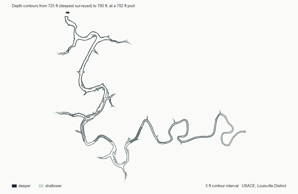
Depth contour map of Buckhorn Lake, drawn from U.S. Army Corps of Engineers, LRL District survey data

12 contour lines at a 5 ft interval, from 725 ft to 780 ft — drawn from the U.S. Army Corps of Engineers, LRL District's own survey geometry, not a schematic.

Deepest point
58 ft
Volume at full pool
32,055 acre-feet

Measured from the top of conservation pool at 782 ft down to the deepest surveyed point at 724 ft. Depths quoted against a flood pool or an older survey come out higher.

Depth data from U.S. Army Corps of Engineers, LRL District. Bathymetry changes slowly — treat it as structure, not as today's water.

U.S. Army Corps of Engineers, LRL District · depth contours

Buckhorn Lake boat ramps and public fishing access

Kentucky Department of Fish and Wildlife Resources lists 6 public access points on Buckhorn Lake.

Access data from Kentucky Department of Fish and Wildlife Resources. Distances are straight-line from our gauge, not driving distance.

Kentucky Department of Fish and Wildlife Resources · public access inventory

Before you go

A Kentucky fishing license covers this water — $24.31 a year for residents. KDFWR sets the rules and is the one that counts.

What it costs, and who is exempt →

Nearby waters today

Questions people ask about Buckhorn Lake

Answered from the same readings as the rest of this page. Where we have no basis for an answer, there is no entry — spot-by-spot local knowledge is not something we can claim for Buckhorn Lake.

Is it worth fishing Buckhorn Lake today?
5 out of 10 — picky. Work for it. The strongest stretch is 3:21 AM–5:21 AM. That number is worked out fresh each morning from the solunar windows, the pressure trend, the water level.
What time should you fish Buckhorn Lake?
Today's major windows run 3:21 AM–5:21 AM and 3:50 PM–5:50 PM, with minor windows at 11:31 AM–12:31 PM and 9:05 PM–10:05 PM. Sunrise is 7:28 AM and sunset 7:18 PM. A major landing on first or last light is the stretch worth setting an alarm for.
What is the water temperature at Buckhorn Lake?
No gauge on Buckhorn Lake measures it, so this is an estimate: roughly 60.8°F, worked out from the 7-day mean of air temperature at NOAA weather station KJKL (Jackson, Carroll Airport). Checked against the lakes that do have a thermometer, that method lands within about 4.5°F of the real reading and was off by 8.3°F at worst. Treat it as a ballpark, not a measurement — and note the bite index above ignores it entirely, because an error that size would move the verdict as often as it would fix it.
What is the water level at Buckhorn Lake right now?
782.11 ft, read at 9:15 AM from USGS station 03280800. Over 24 hours it is up 0.01 ft.
Are water levels rising or falling at Buckhorn Lake?
Rising. The lake is up 0.01 ft in 24 hours and up 0.57 ft over the week. Over the last 8 days it has held between 781.52 and 782.79 ft. Every figure here is a difference between two gauge readings, not a forecast — what the level does next depends on rain and on what the dam releases.
Is Buckhorn Lake full right now?
At 782.11 ft the lake is sitting right at its top of conservation pool of 782 ft, as U.S. Army Corps of Engineers, LRL District defines it. That is a comparison of two elevations, not a percentage of capacity — a reservoir at half its depth holds far less than half its water, so the two are not the same thing.
Can you eat the fish you catch in Buckhorn Lake?
That is a health question and it belongs with the state, not with us. KY publishes fish consumption advisories through its health or environmental agency, and those are the ones that count. We give no eating advice.
Do you need a licence to fish Buckhorn Lake?
Yes. A Kentucky fishing license covers this water, required from age 16. KDFWR sets the rules and is the one that counts.

Where these numbers come from

A Corps of Engineers reservoir on the Middle Fork Kentucky River, gauged by USGS at Buckhorn. No temperature sensor at the gauge.

No one types these in by hand. If a source goes quiet, the page says so instead of showing you yesterday.